
MIKE HYDRO Basin
Optimise river basin management with map-based modelling for integrated water resources management
MIKE HYDRO Basin is the premier map-based modelling software for integrated water resources management. Tailored for water resources planners, reservoir operation managers, and irrigation specialists, it provides a comprehensive toolkit for navigating complex water systems. From analysing alternative designs to fine-tuning management policies, MIKE HYDRO Basin empowers users to optimise river basin systems with unparalleled efficiency.
Its intuitive interface and built-in routines streamline the creation of water usage models, simplifying the delineation of rivers and catchments. It also supports large-scale, multi-year simulations and can deliver real-time decision support. Whether you're strategising for climate impacts or optimising hydro-power and irrigation operations, MIKE HYDRO Basin equips you with the tools to make proactive, informed decisions.
Interested in MIKE HYDRO Basin?
Contact usHow does MIKE HYDRO Basin help?

Special Offer: FREE Classroom Teaching Subscription
Support teaching with MIKE HYDRO Basin. Educators can access a free subscription to make classroom learning more engaging and practical.
No in-house modellers?
Get our expert modellers on board for your consulting projects either as a partner, to provide extended user support, or for model and project reviews. Submit an inquiry
Areas of application

Catchment hydrology and yield analyses
Optimise water yield management with comprehensive simulations that address allocation and shortage concerns.

Climate change resilience and impact
Model and predict the impacts of climate variability on water resource systems.
Contaminant fate and transport
Safeguard water resources by predicting and managing contaminant spread.

Drought and water scarcity
Proactively manage water scarcity by evaluating system vulnerabilities.

Flood risk mitigation and management
Optimise flood management and mitigation through advanced reservoir modelling and real-time decision support systems.

Forecasting and early warning systems
Implement predictive models for hydrological events to support immediate and long-term decision-making.

Integrated water resources management
Facilitate IWRM with tools that support integrated groundwater and surface water use and multi-sectoral planning.

Irrigation scheme optimisation
Predict water demand and improve irrigation performance by analysing water balance, infiltration, and recharge.

Integrated land use planning
Support land use decisions with detailed hydrological models that evaluate how changes impact integrated water resources.

Surface water-groundwater interaction
Analyse surface and groundwater interactions to optimise water allocation and management.

Water quality impact assessment
Ensure basin water quality meets environmental standards using advanced simulations.
Additional capabilities & unique features
Explore our latest support resources, including guides, videos, and FAQs in our Knowledge Base.
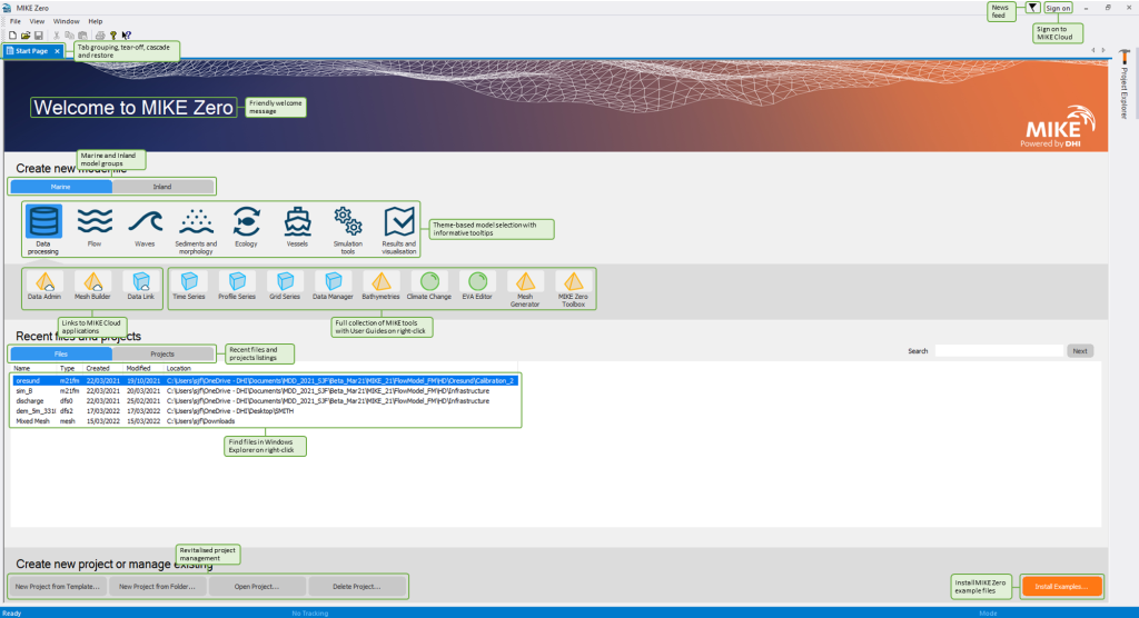
Get more done in less time with the modernised MIKE Zero user interface
Save time and improve your modelling workflows using MIKE Zero’s upgraded editors and viewers. Take advantage of new keyboard shortcuts and themes, improved tabbing, tear off and cascade functionality plus easier access to User Guides and Scientific Documentation.
Access new tools, Cloud applications and an enhanced graphical overview from the redesigned MIKE Zero start page
MIKE Zero, DHI’s fully Windows integrated graphical user interface, is now better than ever! Enjoy easy access to new MIKE Cloud applications and Cloud-enhanced functionality, plus an extended set of MIKE tools within theme-based (rather than product-based) interactive workflows. Ensure important model components such as sources and structures stay at the forefront with a new interactive, customisable floating mapping window. Lastly, the updated tabbing functionality will help you work in a more organised and efficient manner.
Create models in the cloud with no hardware limitations
You can now access MIKE HYDRO Basin on Azure Marketplace, where you can start modelling in the cloud with no hardware limitation in four simple steps. Learn more
Evaluate river routing options
Account for flow routing through larger river basins with the River Routing module that allows you to calculate overall hydraulics and water levels in various river branches.
Analyse water consumption
Develop a greater understanding of water consumption by representing the water withdrawal behaviour of two types of water users: irrigation and regular water users such as municipalities and industrial.
Obtain maximum crop yield
Develop optimal irrigation strategies to obtain maximum crop yield without water spillage and the incurrence of water deficits using the powerful Irrigation module. You can also run irrigation scenarios for additional insight as to how different crops are affected by crop stress.
Track water content and flow in different layers of soil
Understand the amount of water available for soil evaporation and crop transpiration at any time with the Soil module which enables users to track water flow between different layers in a soil profile as well as the time-varying water content in each layer.
Improve hydropower system performance
Perform advanced hydropower simulations to analyse existing systems or evaluate the feasibility of new developments with the Hydropower module. For example, you can calculate conveyance, head losses, tail water level, and backwater effects from cascading reservoirs.
Simulate the performance of multi-purpose reservoir systems
With the Reservoir module, users can simulate the performance of specified operating policies for individual reservoirs. Define desired storage volumes, water levels and releases at any time as a function of current water level, the time of the year, demand for water and losses and gains. In addition, reservoir releases in all types of reservoirs (Lakes, Rule Curve and Pool Allocation) can be controlled for flood mitigation by one or more outlets for each connected node.
Simulate reservoir sedimentation
While not considered a sediment transport model, users can still route sediment through a river network and calculate the potential deposits of sediment in the reservoirs using a specialised Reservoir Sedimentation module.
Expand your horizons
Extend the capabilities of MIKE HYDRO Basin even further by developing your own tools with MIKE SDK. Use the APIs to embed the engine into your own code or decision support system.
Prioritise water allocation
The Global Ranking feature provides users with the ability to prioritise water allocation to water users, hydropower plants and reservoirs independently of their geographical location in the river basin.
Simulate rainfall runoff
With the Rainfall-Runoff module, you can accurately calculate total runoff surface flow in addition to its percolation to groundwater.
- NAM: Simulate overland flow, interflow and baseflow components as a function of the moisture contents in four storages with this lumped, conceptual rainfall-runoff model.
- UHM: Estimate storm runoff using this Unit Hydrograph Model which includes different loss models (constant, proportional) and the SCS method.
Autocal provides users with easy-to-use auto-calibration tools to save time when configuring your Rainfall-Runoff model.
Represent surface-groundwater interaction at the basin scale
Represent the important interaction of groundwater and surface water in the basin by accounting for groundwater recharge, groundwater discharge, seepage (from irrigation fields, rivers, reservoirs and canals) and impacts of groundwater pumping on the groundwater levels and river flows.
Perform water quality simulations
Water quality simulations can be run using standard, predefined MIKE ECO Lab templates or adjusted to user-defined templates for custom water quality models.
Determine catchment pollutant concentrations
Using the Load Calculator, you can determine the amount of pollutants absorbed in the flow paths through catchments and groundwater towards a river network. Specify different pollutant sources related to farming, agriculture, or industrial activities including animal or human waste, sewage sources or fertiliser. Users can also model distance specific decay or the retention of pollutants.
Customise the Map View to suit your preferences and requirements
The Map View is the focal point of each MIKE HYDRO Basin model session. It can be customised to suit individual preferences and requirements and offers a variety of configuration options. For example, you can visualise background maps (e.g. Google Maps), background layers (shape files, raster and images) as well as Digital Elevation Models.
Analyse results with ease
The detailed outputs from MIKE HYDRO Basin offer an easy-to-understand overview of scenario results, such as water usage, water allocation deficit, generated power, reservoir releases, water losses and mass balance. In situations where you need to check model results against measurements made downstream, you can also create calibration plots at any point in a river network.
Let's get started
Learn how your project can benefit from this map-based modelling software for integrated water resources management.


